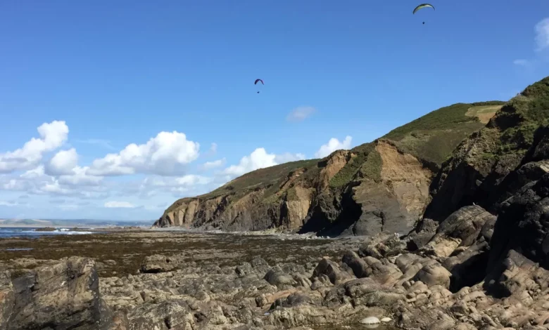
Bideford is a historic port town on the estuary of the River Torridge in north Devon, south-west England. Credit: Shadrick et al.
Rocky coastlines could retreat more rapidly in the future due to accelerating sea level rise. This is especially concerning because rock coasts make up over half the world’s coastlines.
This is the finding of new Imperial College London research that modeled likely future cliff retreat rates of two rock coasts in the UK. The forecasts are based on predictions of sea level rise for various greenhouse gas emissions and climate change scenarios.
Rock coasts, traditionally thought of as stable compared to sandy coasts and soft cliffs, are likely to retreat at a rate not seen for 3,000-5,000 years, according to the study’s results.
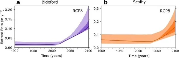
At the UK study sites in Yorkshire and Devon, this will cause rock coast cliffs to retreat by at least 10-22 meters (33-72 feet) inland. The rate of erosion is likely between three and seven times today’s rate and potentially up to tenfold.
Senior author Dr. Dylan Rood, of Imperial’s Department of Earth Science said: “Coastal erosion is one of the greatest financial risks to society of any natural hazard. Some rock cliffs are already crumbling, and within the next century, rock coast erosion rates could increase tenfold. Even rock coasts that have been stable in the last hundred years will likely respond to sea level rise by 2030.”
Globally, coasts are home to hundreds of millions of people and hundreds of billions of dollars of infrastructure like homes, businesses, nuclear power stations, transport links, and agriculture.
The researchers are calling on policymakers, planners, and insurers to take action to classify rock coasts as high-risk areas in future planning for climate change response. The authors also say we need to limit climate change by achieving Net Zero as an immediate priority.
Dr. Rood added: “Rock coast erosion is irreversible: now is the time to limit future sea level rise before it’s too late. Humanity can directly control the fate of our coastlines by reducing greenhouse gas emissions the future of our coasts is in our hands.”
The research will be published today (November 18) in the journal Nature Communications.
A rocky road
The new study is the first to validate models of the expected erosion of hard rock coasts from sea level rise using observational data over prehistoric timescales. Previous studies have mostly focused on theoretical models of soft, sandy coasts. The new results suggest that as sea levels continue to rise, the rate of rock coastal erosion will also accelerate.
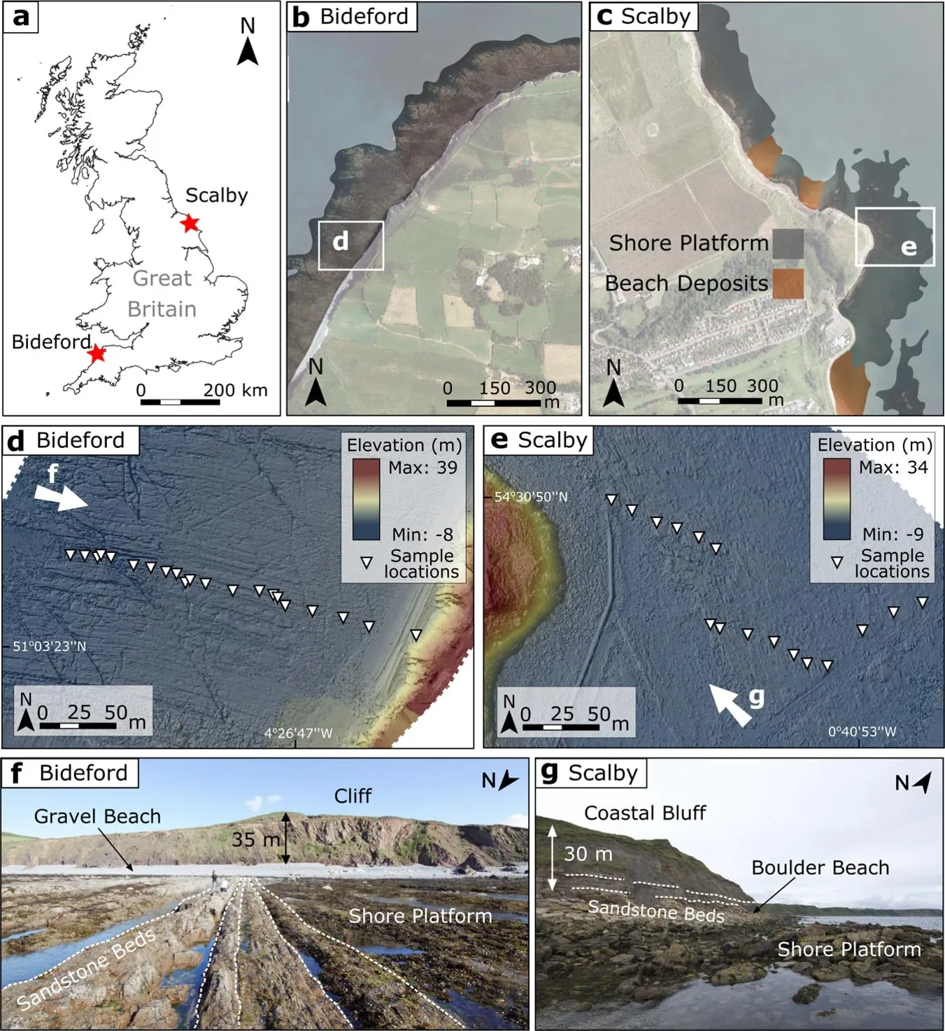
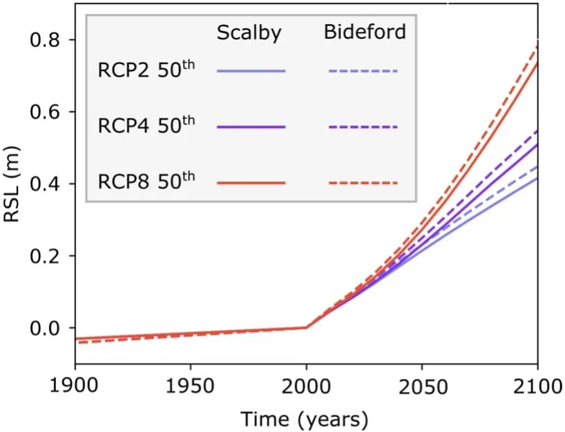
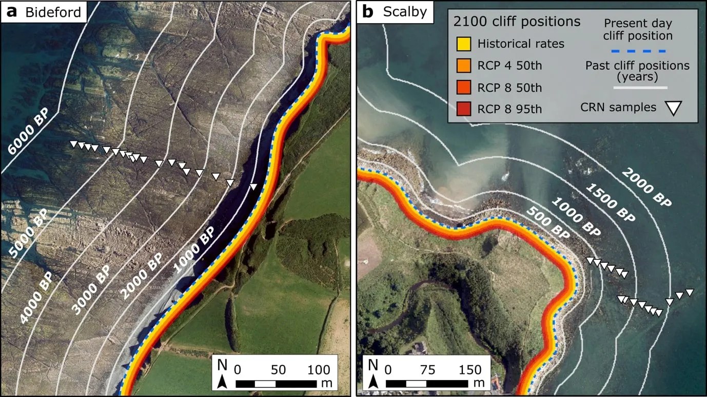
To study the future rate of erosion, the researchers looked at past and present cliff retreat rates on the coastlines near Scalby in Yorkshire and Bideford in Devon, finding that by 2100 they will likely retreat by 13-22m and 10-14m, respectively.
They collected rock samples and analyzed them for rare isotopes called cosmogenic radionuclides (CRNs) that build up in rocks exposed to cosmic rays. Concentrations of CRNs in rock reveal how quickly, and for how long, the rock has been exposed, reflecting the rate of erosion and retreat.
They combined these data with observed coastal topography to calibrate a model that tracks the evolution of these rock coasts over time, before comparing them with rates of past sea level change dating back 8000 years. They found that the rate of coastal erosion on these two sites has closely matched the rate of sea level rise.
The researchers say this is clear evidence of a causal relationship between cliff retreat and sea level from which future forecasts can be made, and that rock coasts are more sensitive to sea level rise than previously thought. The findings, they say, could be applied to rock coasts worldwide because the rock type is common globally, and similar hard rock coasts are likely to respond in a similar way to sea level rise.
Lead author Dr. Jennifer Shadrick, who conducted the work in Imperial’s Department of Earth Science and Engineering as a member of the NERC Science & Solutions for a Changing Planet Doctoral Training Partnership, and now works in the marine and coastal risk management team at JBA Consulting, said: “Sea level rise is accelerating, and our results confirm that rock coast retreat will accelerate in line with this. It isn’t a matter of if, but when.
“The more positive news is that, now that we have a better idea of magnitudes and timescales, we can adapt accordingly. The more data we have on the effects of climate change on sea level rise and coastal erosion, the more we can prepare by championing urgent policies that protect coasts and their communities.”
Sea level rise
As the climate warms, sea levels are forecast to rise one meter by 2100 unless greenhouse gas emissions are reduced.
This study is the first to confirm with observational data that the rate of past coastal erosion followed the rate of sea level rise over prehistoric timescales. The researchers say this erosion was driven by waves, which will likely get larger and more forceful as future sea level rises, and more land is given over to the sea.
While this study looked at the effects of sea level rise, it did not account for the effects of stronger storms, which some studies forecast will happen more frequently due to climate change. Next, the researchers will adapt their model to also forecast the rate of cliff retreat for softer rock coasts, such as chalk.
Dr. Rood said: “Our study did not account for the effect of increased storms, which may become stronger and more frequent in the future as the climate changes, on wave-driven cliff erosion. However, increased storms would only speed up the cliff retreat even more than our forecasts. This is another angle to the climate crisis we will account for in future studies to give a more complete picture of likely rates of rock coast erosion. We are also looking to improve our models for softer rock coasts where erosion other than by waves is more important.”
Dr. Shadrick said: “The findings are a stark warning that we must better adapt to coastal retreat or face the loss of the people, homes, and infrastructure that call coastal areas home.”
Study co-author Dr. Martin Hurst at the University of Glasgow said: “The implication is that rock coasts are more sensitive to sea level rise than previously thought. We need to pay more attention to how our rock coasts continue to erode as sea levels rise.
“Heightened erosion risks at our coasts will continue throughout this century. Even if we achieve Net Zero tomorrow, a substantive amount of sea level rise is already baked in as our climate, glaciers, and oceans continue to respond to the emissions that have already taken place.”
Reference: “Sea-level rise will likely accelerate rock coast cliff retreat rates” 18 November 2022, Nature Communications.
DOI: 10.1038/s41467-022-34386-3
This study was funded by the Natural Environmental Research Council (NERC), the British Geological Survey (BGS), and the Australian Nuclear Science and Technology Organisation (ANSTO).